

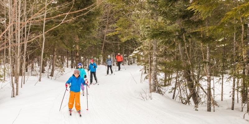
Maintained by a dedicated crew, the trail system at Maine Huts & Trails is unforgettable. Featuring winding switchbacks, sandy paths along mountain streams, natural bridges, and incredible views, the trails leading to the huts are some of the best in the world. When using the trail system, you’ll be following white and blue diamonds; white for the main trail which is groomed for skiing in the winter, and blue for ungroomed side trails.
Our trails connect with others in the area, managed by town of Carrabassett, Sugarloaf, and more. Please visit their pages for trail conditions, closures, and more.
Download Full Trail Map | Distance and Elevation Detail | Current trail conditions | Interactive Trail Map
Maine Huts Maintained Trails

Find trails to your hut. Jump to:
STRATTON BROOK HUT TRAILS
Closest Trailhead: Rte. 27/Stratton Brook Trailhead: 3.1 miles
Other Trailheads
Campbell Field Trailhead: 3.00 miles - NO OVERNIGHT PARKING
Sugarloaf Outdoor Center: 3.6 miles - NO OVERNIGHT PARKING
Airport Trailhead: 4.7 miles – (Drop point for gear shuttles to Stratton Brook Hut)
Maine Hut Trail/Newton’s Revenge
Newton’s Revenge starts with a gentle uphill slowly getting steeper while winding its way up via switchbacks. Trail has both doubletrack and mountain bike singletrack. Great climb and descent trail for intermediate bikers and advanced skiers. Total distance is about 3 miles, or about 1.5 hours.
See Highlighted Map Section >>
Oak Knoll
Oak Knoll is an intermediate-level single track with beautifully crafted stone switchbacks. A must-ride for mountain bikers and winter snowshoers. This trail branches off from Newton’s Revenge and winds through the woods and exposes great views of Sugarloaf. Distance from Stratton Brook trailhead is just under 4 miles and will take about 3 hours hiking.
See Highlighted Map Section >>
Crommett’s Overlook Trail from Airport Trailhead
A steady trail leading up to Stratton with phenomenal views of Sugarloaf Mountain. From Airport Trailhead, cross over the Carrabassett River and turn left onto the Narrow Gauge Pathway. Continue on the pathway, then take a right onto the Crommett's Overlook Trail. The trail gradually ascends for the next 3 miles, with Crommett’s Lookout offering mountain views. The trail will intersect with Newton’s Revenge. Continue right to ascend to Stratton Hut and Oak Knoll trail or turn left to descend Newton’s Revenge down to the Narrow Gauge Pathway.
See Highlighted Map Section >>
Poplar Stream Hut to Stratton Brook Hut (7.6 miles, approx. 3-6 hours):
A hut connecting trail with steady descents and ascents. Streams, bridge crossings, switchbacks and mountain views are on the menu! Exit Poplar Hut and make a left onto the Maine Hut Trail. Continue downhill on the sloping and scenic Maine Hut Trail, eventually crossing Poplar Stream. After the bridge, cross over the Carriage Road and after 1.2 miles the Maine Hut Trail intersects with the Narrow Gauge Trail. At this intersection, continue on the Narrow Gauge for 0.8 miles, then veer right onto the Maine Hut Trail/Crommett’s Overlook Trail. Continue on this trail for 3.1 miles. The trail intersects at Newton’s Revenge, where you will take a right for a steep uphill ski to the Stratton Brook Hut.
See Highlighted Map Section >>
POPLAR STREAM HUT TRAILS
Closest Trailhead: Airport Trailhead: 3.3 miles (Drop point for gear shuttles to Poplar Stream)
Other Trailheads
Campbell Field Trailhead: 6.5 miles - NO OVERNIGHT PARKING
Sugarloaf Outdoor Center: 7.8 miles - NO OVERNIGHT PARKING
Rte. 27/Stratton Brook: 8.1 miles
Flagstaff Trailhead: 10 miles
Maine Hut Trail/Airport Trail/Poplar Stream Trail
A beginner/intermediate forest trail which starts out flat and then increases to rolling terrain and steady up-hills. Park at the Airport Trailhead, then cross the Carrabassett River and follow the Maine Hut Trail into the woods. The trail crosses the Carriage Road (closed, please do not wander!), and continues over Poplar Stream. A long and gradual ascent continues up to Poplar Stream Hut. Distance is about 3.3 miles.
See Highlighted Map Section >>
Warren’s Trail
This winding trail ascends through ancient tree growth and makes for a great loop to see waterfalls and wildlife. Just before the Poplar Stream footbridge take a left onto Warren’s Trail, following the west side of Poplar Stream. This is a hiking/snowshoe trail only, and is not groomed in winter.
See Highlighted Map Section >>
Larry’s Trail
The scenic trail follows the east side of Poplar Stream, across the way from Warren's Trail. A half mile after the footbridge over Poplar Stream, take a left on Larry’s Trail. Cross over the bridge for a great view of South Brook Falls. Adventurous trekkers can jump in and cold off. Stone steps lead back up to intersect with Warren’s Trail and the Maine Hut Trail. This is also a hiking only summer trail, and ungroomed backcountry trail in winter.
See Highlighted Map Section >>
Stratton Brook Hut to Poplar Stream Hut via Maine Hut Trail (7.6 miles, approx. 2-4 hours)
Intermediate level trail connecting the two huts. Carefully descend from Stratton Brook and take a sharp right onto Newton’s Revenge. When the trail intersects with the Crommett’s Overlook trail, turn left and follow sloping downhill for 3.1 miles until intersection with the Narrow Gauge Pathway. After .8 miles, take the Maine Hut Trail/Airport Trail into the woods. The trail starts out flat and then increases to rolling terrain. Cross over the Carriage Road (closed, do not wander!) and continues over Poplar Stream. The trail starts out flat and begins to climb, leveling off for the last mile. Continue over a foot bridge and follow signs to the Hut.
See Highlighted Map Section >>
Flagstaff Lake Hut to Poplar Stream Hut: (11.8 miles, approx. 4-6 hours)
A true backcountry trek, this nearly 12 mile trails travels along the lake, bog, woods, and higher elevations. The Maine Hut Trail follows along Flagstaff Lake through the woods, then gradually climbs to the Halfway Yurt. After a snack break and sitting by the woodstove, descend from the Yurt. There are a few road crossings over Long Falls Dam Road. The trail then winds through tall pines, crossing a few dirt roads until coming out on the Sticky Trail, a fun rolling trail on both skis and mountain bikes. Continue on the Sticky Trail another 3.2 miles, and at the trail intersection, turn left and you will reach the hut. A long trail, not for beginners!
See Highlighted Map Section >>
FLAGSTAFF HUT TRAILS
Closest Trailhead: Long Falls Dam/Flagstaff Trailhead: 2.2 miles (Drop point for gear shuttles to Flagstaff Lake)
Other Trailheads
Big Eddy/Grand Falls: 3.8 miles – CURRENTLY NOT GROOMED OR MAINTAINED. USE AT OWN RISK.
Maine Hut Trail from Flagstaff Trailhead
This easier trail offers gentle inclines and declines and is a great backcountry option for all abilities. The 2.2-mile path winds through forest full of birch and pine trees, and lots of wildlife.
See Highlighted Map Section >>
Shore Trail
This hike/snowshoe trail branches off from the Maine Hut Trail and follows along the shore of Flagstaff Lake. Hidden beaches, lake overlooks, and a sandy point with view of the Bigelow Mountain Range are all packed into this 2.2 mile trail.
See Highlighted Map Section >>
Poplar Stream to Flagstaff Lake Hut (11.8 miles, approx. 4-6 hours): Hiking and skiing
See Highlighted Map Section >>
Summer Bikers: After the second Carriage Road x-ing, follow the gravel road to E Flagstaff Road, and ride down Long Falls Dam Road until the trail to the hut appears 1.2 miles on the right.
GETTING TO GRAND FALLS HUT
Trail closed due to bridge work planning - Grand Falls Hut from the Big Eddy Trailhead
Trail closed due to bridge work planning - West Forks Trailhead
Use at own risk - Lower Enchanted Trailhead
Note: Parking at the Big Eddy Trailhead is not managed by Maine Huts & Trails and is a public parking area.